When it comes to the sheer scope of the Roman architectural prowess, we tend to relate to the fascinating legacy mostly through the expansive ruins preserved by the many archaeological sites across the world. But as it turns out history can actually be recreated, if not on the physical level, but at least on the virtual scale – by the admirable efforts of entire teams of researchers and artists. So without further ado, let the proverbial phoenix of the renowned ancient Roman cities rise, as they are presented via superbly done animated digital reconstructions and illustrations.
Pompeii
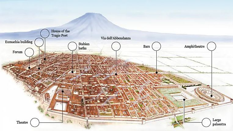
Pompeii, the ancient Roman town-city near modern Naples, boasted an assortment of baths, houses, temples, public structures, graffiti, frescoes, and even a gymnasium and a port. But more than any of these antediluvian avenues, the city is best known for a brush with disaster for over 400 years, after its rediscovery way back in 1599 AD.
In fact, the site of Pompeii has been a popular tourist destination for over 250 years – thus merging an unfortunate episode of history and the innate level of human curiosity. However, beyond just the ‘popular’ impact of the disaster, there was the historical city of Pompeii – a thriving Roman settlement with over 11,000 in population.
In fact, by the late 1st century AD, Pompeii, as a Roman city, was known for its export of wine and its resort-like characteristics (which explains the bevy of ancient ‘holiday homes’ in the city). To that end, the folks over at Altair4 Multimedia have concocted a superb animation (above) that aptly presents the historicity of Pompeii, before it was ‘marred’ by catastrophic events.
As for the catastrophe, Pompeii (and the region of Campania), known for minor seismic activities, was afflicted by a massive earthquake in 62 AD. As a consequence, a great number of structures, including temples, roads, and houses, collapsed, while fires and smoke made their severe presence felt in many corners of the city.
In spite of the ensuing anarchy and a significant number of casualties, parts of the infrastructure and forum were rebuilt, including the Central Thermal Baths. Many new structural projects were also initiated, like the Temple of Vespasianus and the Temple of Lares.
And while Pompeii experienced increasing degrees of seismic activities in the following years, the catastrophe struck in the year 79 AD, when Vesuvius erupted. Shrouded by displays of smoke, fire, explosions, and layers of pumice particles, the city was soon covered in flecks and fragments of ash discharged by the eruption.
The buildings were already beginning to collapse from the weight of such heavy deposits, the ‘shock-and-awe’ came forth hours later – in the form of destructive waves of superheated volcanic matter and gas (pyroclastic flows) from the imploding cloud over the volcano.
According to some studies, it might have been the heat rather than asphyxiation (caused by ash) that resulted in many untimely deaths inside the buildings. The above animation made by the Zero One team was showcased at a 2009 exhibition named aptly as the ‘ A Day in Pompeii’, in the Melbourne Museum.
Suffice it to say, the exhibition used 3D renderings to present a more accurate picture of the impending disaster that took place in 79 AD, and its baleful effects in the span of 48 hours surrounding the eruption of Mount Vesuvius.
Carnuntum
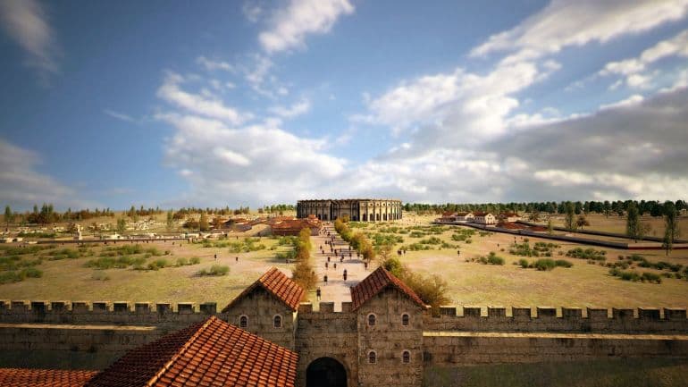
Carnuntum was founded as a Roman legionary fortress (castrum legionarium), and it also served as the headquarters of the Pannonian fleet (circa 50 AD). And by the early 2nd century AD, the settlement was transformed into the capital of the Pannonia Superior province, possibly boasting around 50,000 population.
Suffice it to say, given such an impressive scale of the town, it was archaeologically important to establish the authentic scope of the ancient Roman settlement. And that is exactly what researchers have achieved with a combination of state-of-the-art technologies such as high-resolution magnetometers and ground-penetrating radar systems.
To that end, a collaborative effort between Ludwig Boltzmann Institute for Archaeological Prospection and Virtual Archaeology (LBI ArchPro) and the ZAMG (Central Institution for Meteorology and Geodynamics) has resulted in an incredible ‘scan’ of the ancient Roman city of Carnuntum, located in proximity to the modern-day metropolis of Vienna, Austria.
Fueled by the discovery of a gladiator school in the area (in 2011), this time around the researchers utilized ground penetrating radar to reveal the remnant subterranean plans and structures of the settlement. In essence, they didn’t need to resort to the physical excavation of the site, thus resulting in the fascinating case of detailed virtual archaeology.
Corinth
Ancient Corinth was one of the most powerful and important of the Greek city-states, with the settlement itself boasting a population of over 90,000 during the 5th century BC. Guarding the isthmus which connects mainland Greece with the Peloponnese, the strategic location of the city manifested itself throughout its history, with commerce, trade, navies, and wars playing their crucial roles in the Corinthian scheme of things.
The unique geography of the city (with fertile lands and natural springs) even enticed the later Romans, who destroyed the original settlement after their victory over the Achaean League in 146 BC. And Julius Caesar was then instrumental in ‘re-founding’ Colonia Laus Iulia Corinthiensis (‘colony of Corinth in honor of Julius’) circa 44 BC, thus leading to its subsequent revival as the provincial capital of Achaia.
Considering all these dynamic historical factors, animator extraordinaire Danila Loginov has virtually conceived the ancient version of Corinth, circa 2nd century AD. He goes on to provide a short summary of his recreation –
Reconstruction of ancient Corinth city as it was in II century AD, in the Roman Empire ages. It contains the whole city, the central part with Agora, the temple of Apollon, theater, and Odeon, and also hippodrome, gymnasium, the temple of Asclepius and amphitheater. Near the city is Acrocorinth mountain with fortress and temples.
Rome
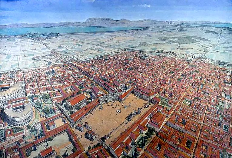
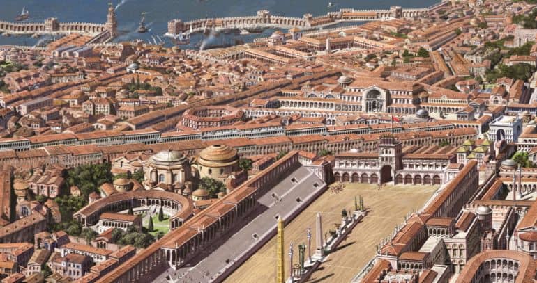
An incredible fruit of collaboration between the Rome Reborn project and Khan Academy, the animation (below) gives us a fascinating tour through the ancient megacity in its arguably peak form in 320 AD. In essence, this was the period when Emperor Constantine was successful in once again centralizing the power of the state, while also endowing freedom of worship for Christians.
In many ways, this short epoch of stability became the ‘last hurrah’ of glory for the ancient stronghold – before the Roman Empire was divided, and consequently, Rome lost its significance in the coming centuries.
As overseer of the Rome Reborn project, Dr. Bernard Frischer makes it clear why 320 AD was chosen as the subject of the video tour –
[320 AD was] the peak of Rome’s development, certainly in terms of public architecture, for the simple reason that the Emperor at this time was Constantine the Great.
And even beyond just the ‘starring’ emperor, the period of Constantine is crucial for history because that was the time when Rome possibly reached the peak of its population (that easily crossed the threshold of a million people) and urban development.
Moreover, even from the overview of architectural triumphs, this period mirrored the rise of major Christian churches, while the post-era (after 320 AD) defined the unfortunate abandonment of major engineering or constructional undertakings. Simply put, most of what we know about Rome in our modern age comes from this age, along with the glorious preceding years before the rise of Constantine.
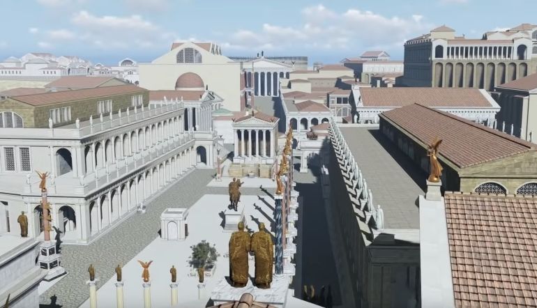
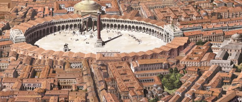
As for another 3D rendering of the ancient metropolis, reconstruction expert Danila Loginov has presented (above) what he has touted as the most detailed recreation of ancient Rome, once again circa 320 AD. In Loginov’s own words –
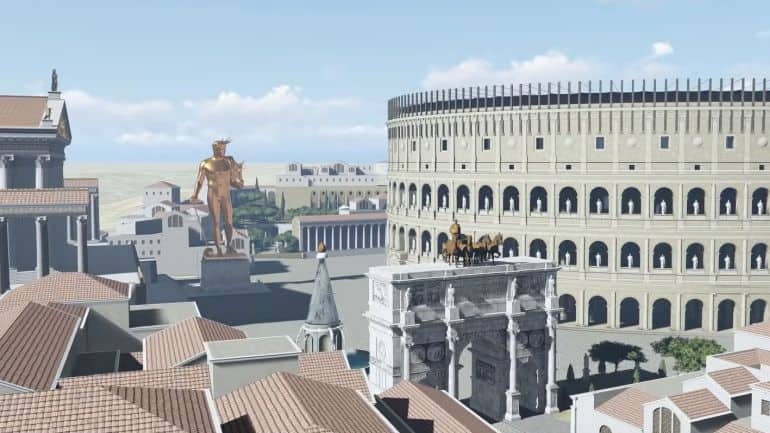
We are happy to present a new, 3rd trailer of our project, which dedicated to the ancient Rome 3D reconstruction, as it was in 320 AD. Previously we have shown the Forums area, and also Palatine and Capitolium hills with their palaces and major temples. Now, upon the user requests, we have focused on the other location of the center of ancient Rome – it’s now the area around Colosseum. This great amphitheater surely dominates all over around territory, in the meantime, there were a number of magnificent buildings which are also worth to be reconstructed.
These are baths of Trajan and Titus, the statue of Colossus Solis, arches of Titus and Constantine, Ludus Magnus, the temple of Divine Claudius. Our team spent some time to recreate this area along with all minor buildings as a complex and added it to the model which has been already done. So we have now almost the entire center of ancient imperial Rome already recreated!
Constantinople
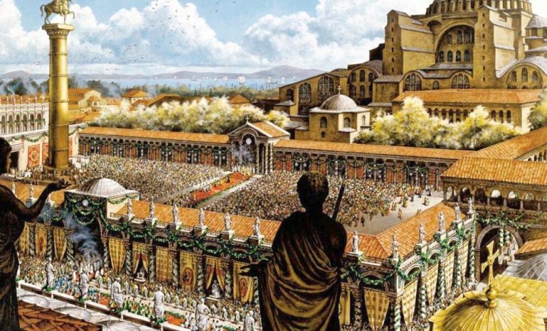
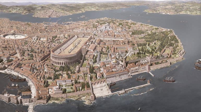
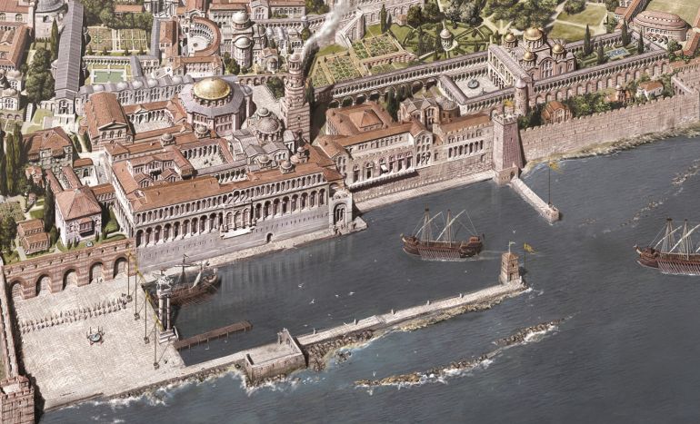
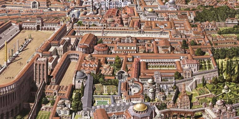
Constantinople was the largest and wealthiest city in Europe from the 5th AD to the early 13th century AD. To that end, it was Emperor Constantine who truly elevated the architectural scope of the original settlement, by ‘re-founding’ it as Nova Roma (New Rome or Νέα Ῥώμη). This symbolic overture mirrored the entire shifting of the capital from original Rome to Byzantium in 330 AD, which was then called Konstantinoupolis (or City of Constantine).
In fact, the massive defense systems of the major Roman city [entailing the Theodosian Walls] were equally matched by its impressive architectural masterpieces, ranging from the magnificent Greek Orthodox cathedral of Hagia Sophia, the humongous Hippodrome of Constantinople (which was capable of possibly holding over 50,000 spectators) to the Great Palace of Constantinople (or Palatium Magnum or Μέγα Παλάτιον) and the triumphal Golden Gate of the complex Land Walls.
In reference to the flurry of these architectural and engineering credentials, Constantinople in itself was also called Roma Constantinopolitana, sometimes accompanied by prestigious titles such as Basileuousa (Queen of Cities) and Megalopolis (the Great City).
Inspired by the wealth of complex spatial elements, artist extraordinaire Antoine Helbert painted an entire collection of illustrations (presented below) that portray the historical scope of the last great Roman city in its hey-days from the 4th to the 13th century AD. His works, in his own words, cover the numerous plans, elevations, and sections of the major monuments of Constantinople that date from that extensive time frame of 800 years.


Be the first to comment on "Visual Reconstruction of 5 Roman Cities You Should Know About"