In the modern context, we tend to relate to ancient cities mostly through the expansive ruins preserved by the many archaeological sites across the world. But as it turns out history can actually be recreated, if not on the physical level, but at least on the virtual scale – by the admirable efforts of entire teams of researchers and artists. So without further ado, let the proverbial phoenix of the renowned ancient cities rise, as they are presented via superbly done animated digital reconstructions.
Contents
- Ur (circa 21st century BC)
- Knossos (circa 17th century BC)
- Amarna (circa 14th century BC)
- Babylon (circa 6th century BC)
- Athens (circa 5th century BC)
- Alexandria (circa 51 BC)
- Pompeii (circa 1st century AD)
- Corinth (circa 2nd century AD)
- Rome (circa 320 AD)
- Constantinople (circa 5th century – 13th century AD)
Ur (circa 21st century BC)
Like many great cities of history, Ur started out as a lowly village in the Ubaid Period of Mesopotamia, close to circa 4th millennium BC. However, by virtue of its ‘convenient’ location by the Persian Gulf, nearby to the point where the great rivers Tigris and Euphrates met, the ancient settlement emerged as a major trading hub and one of the richest settlements of the region (by the Bronze Age), with its commercial networks connecting realms as far as India.
And while the current location of Ur is further inland due to millennia of silting of both rivers, the historical legacy of the great Mesopotamian city is still prominent, as can be gathered from the impressive (half-restored) remnants of the Ziggurat of Ur which housed the shrine of Nanna.
The first of the digital reconstructions comes in the form of an animation/image slide that presents the grandiosely conceived scope of the Ziggurat of Ur, a magnificent structure that dominated the cityscape of the flourishing settlement. This was complemented by the locational aspect of the ancient city itself, with its formidable walls also caressing the bends of the Euphrates.
The royal scale of the city of Ur is aptly captured by the second animation concocted by the resourceful folks over at Zero One Animation –
Knossos (circa 17th century BC)
Often heralded as one of Europe’s oldest cities, Knossos is the largest Bronze Age archaeological site in Crete. In fact, the urban character of the ancient site harks back to circa 7000 BC, with the establishment of the first Neolithic settlement in the area.
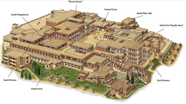
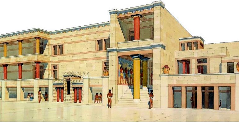
As for its historical significance, the Knossos Palace with its ‘labyrinth’ of spatial elements (including living spaces, storage rooms, and even working areas), was the ceremonial as well as the political center of the Minoan civilization. To that end, it has been estimated that the palace complex and its surrounding urban area (possibly) boasted a population of around 100,000 at their peak, circa 1700 BC.
Historically, the adoption of large-scale architectural projects by the Minoans of Crete rather mirrored their profitable endeavors in maritime trade and even land-based commerce. In fact, the first Palace at Knossos (built circa 1900 BC) was constructed upon the remnants of an existing urban center. The scale of this massive building complex can be comprehended from the extensive coverage that encompassed a whopping 150,000 sq ft of the area – thus being equivalent to two-and-a-half American football fields.
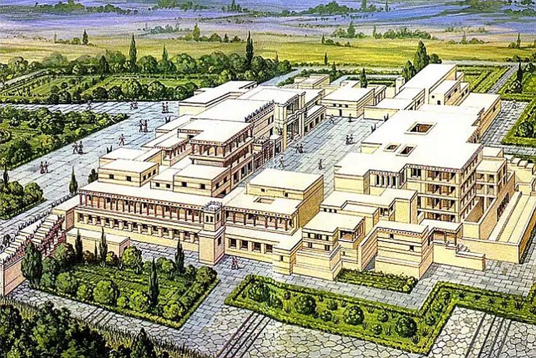
As for the core plan, the palace was built around a central courtyard and was spatially complemented by a flurry of storage areas, very thick walls, and perplexing basins. Considering these varied architectural elements, the ancient Palace of Knossos was actually more than just a royal residence. It was rather conceived as a city-center complex, with structural attributes designed to serve civic, religious, and economic purposes.
The resourceful folks over at Greek High Definition have concocted a superb animation that aptly represents the scale and scope of the massive Palace at Knossos with its intricate layout of passages and corridors, accompanied by a flurry of frescoes and pottery. There is also a resourceful video from Flipped Prof presented above.
For the second of the digital reconstructions, we have a high-definition preview of the Palace at Knossos with spatial details like Queen’s Megaron with its famous Dolphin fresco. The video was sourced from ReaBits’ YouTube Channel.
Amarna (circa 14th century BC)
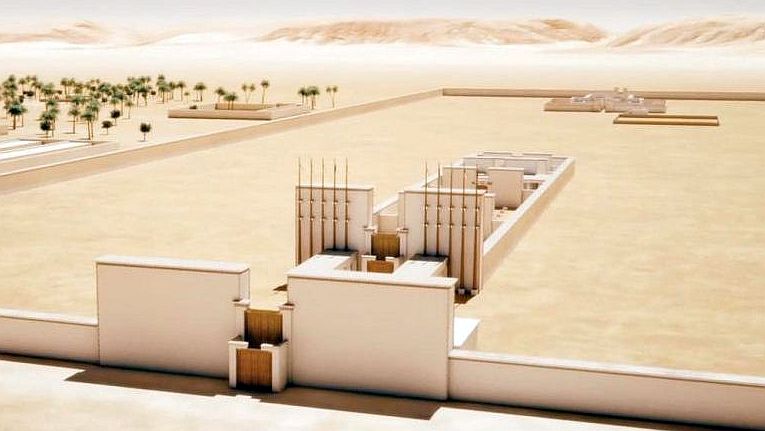
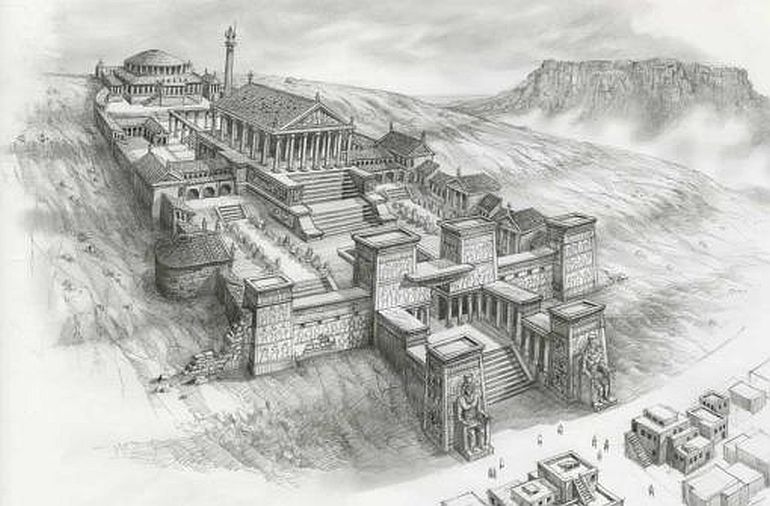
The royal ancient city of Amarna was a relatively ‘new’ settlement if viewed from the perspective of Ancient Egyptian history. Built almost 1,200 years after the Great Pyramid (circa 1346 BC), the entire city was actually constructed on a virgin site, on the orders of the Pharaoh Amenhotep IV – who was later known as Akhenaten.
And while this urban scope was situated almost midway between Cairo (Giza) and Luxor, on the east bank of the Nile River (presently in the Egyptian province of Minya), the city both inspired and instigated various sections of the Egyptian elite – since it was dedicated to Aten, a solar deity who was proclaimed by the Pharaoh to be above the other Egyptian gods. In essence, Akhenaten declared a monotheistic (or possibly henotheistic) mode of religious affiliation across all of Egypt, with the worship centered around Aten.
But while Akhenaten was ‘officially’ discredited after his lifetime, his successors and the later dynasties couldn’t impeccably destroy his heritage. That is because, much like his radical thoughts on the Egyptian pantheon, the ancient city of Amarna boasted revolutionary architecture. For example, most of the temples were constructed without any roofing, thus symbolically allowing the unobstructed passage of the effulgent rays of the solar deity on the worshipers inside.
But even more importantly, many of these monumental structures were built with the use of standardized stone bricks known as Talatats (as opposed to the unwieldy huge blocks of stone). So while the city of Amarna was physically razed from the face of the earth by the later ‘traditionalists’, its interesting architectural features have caught the attention of historians and archaeologists – thus unintentionally preserving the legacy of Akhenaten.
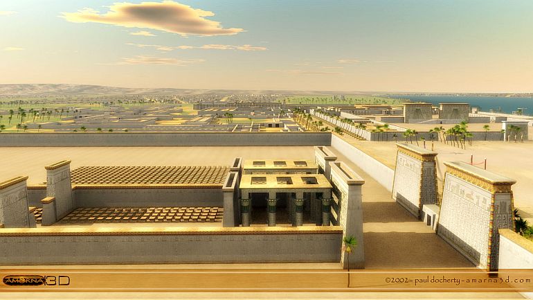
To that end, the experts over at Archéovision have presented one of the digital reconstructions of the royal city of Amarna with incredibly detailed 3D rendering techniques.
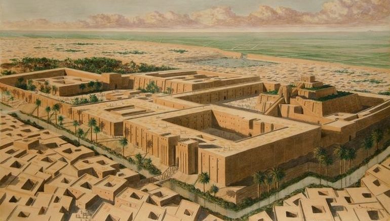
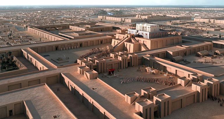
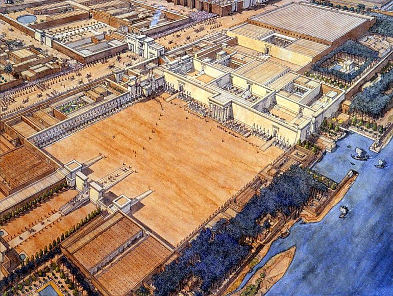
Babylon (circa 6th century BC)
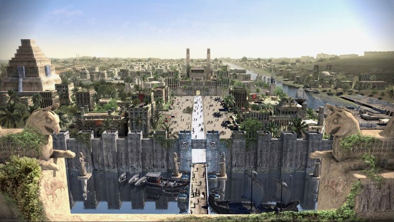
When it comes to the historically rich region of Mesopotamia, Babylon is arguably the most renowned of all cities. An ancient settlement that harks back to the dominions of Sargon of Akkad (circa 24th century BC), Babylon possibly started out as a small town in the backdrop of mighty cities like Ur, Uruk, and Nippur.
However, by the time of the ascension of Hammurabi the Great (the sixth king of the Amorite dynasty) in 1792 BC, Babylon became the major capital of the city-state of ‘Babylonia’, known as Mât Akkadî or ‘the country of Akkad’ in contemporary Akkadian. The very term ‘Babylon’ is of Greek origin and it is possibly a rough translation of Babillu – which in Semitic pertains to the conjunction of two words Bâb (gate) and ili (gods), thus suggesting the location of Babylon as the ‘gate of the Gods’.
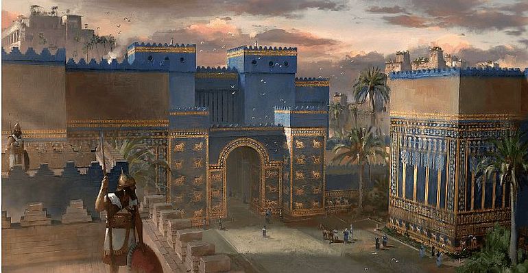
As for Hammurabi, while the ruler is known for his famous law code in our present times, the king in his contemporary prime was renowned as an exalted conqueror whose empire stretched across the entire region of Mesopotamia. That was a seriously impressive feat considering his initial city-state around Babylon was only around 50 sq km. Consequently, the expansion of the realm heralded the grandeur of Babylon, a city paradoxically admired and despised by different sets of people and cultures.
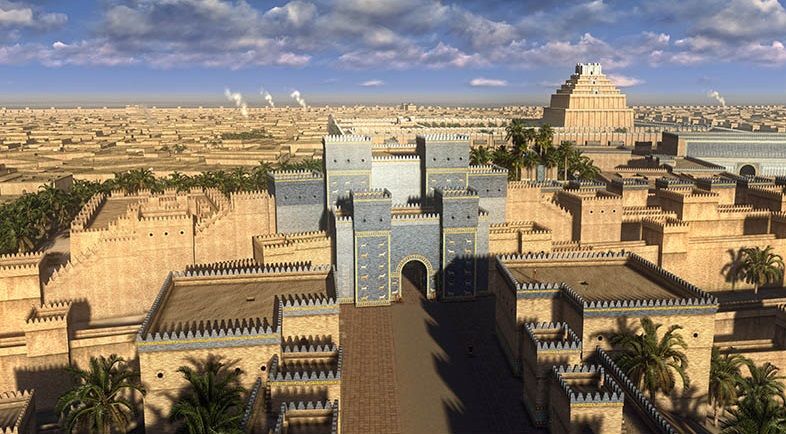
One of the digital reconstructions of ancient Babylon pertains to the video below which presumably showcases the royal city in its architectural peak during the reign of Nebuchadnezzar, in circa 6th century BC. And while the animation does flaunt a bevy of gorgeous 3D rendering techniques, it SHOULD BE NOTED that the creators have taken some artistic license to demonstrate the grandeur of Babylon.
Few of these ‘anachronistic’ examples would relate to the dressing style of the inhabitants (which seems more akin to later Arab styles) and the portraiture of Achaemenid Persian motifs on some walls.
The second of the digital reconstructions (presented below) with more authentic depictions was made for the Mesopotamia exhibition of the Royal Ontario Museum, by the folks over at kadingirra.com –
Athens (circa 5th century BC)
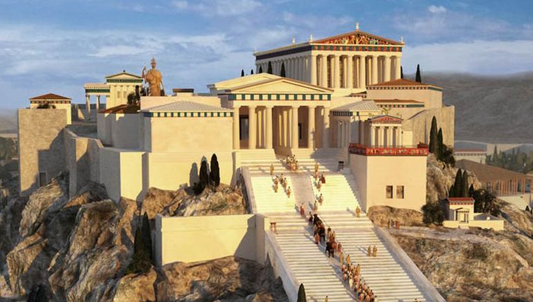
The very word Acropolis literally refers to ‘upper city’ in Greek, and thus can be associated with citadels or groups of buildings constructed atop an elevated site (often hills with precipitous sides). To that end, the famed Acropolis (or Ἀκρόπολις in Ancient Greek) of ancient Athens is one of the still extant ancient citadels that has survived the ‘archaic’ times.
Symbolizing the power of Athens with its literal height, the history of this tall rocky outcrop (of 490 ft) incredibly goes back to around 3500 BC, thus making it older than even the Great Pyramid. And while it started out as a strategic fortification of the surrounding settlement, the site of Athens’ Acropolis was given both a political and religious makeover by the classical period (circa 5th century BC), with its impressive array of temples and monuments – including ancient structures like the Parthenon, the Propylaia, the Erechtheion; all exemplifying features of ancient Greek architecture.
Altair4 Multimedia has concocted one of the digital reconstructions that present both of the imposing Acropolises from two primarily ancient Greek cities (Athens and Syracuse) – thus providing us with a glimpse into the Greek architectural fabric that extended throughout the Mediterranean.
The second of the digital reconstructions of Athens presents a more expansive overview of the ancient city (made by the folks over at www.ancientathens3d.com). Interestingly and quite impressively, the Acropolis in itself was an elevated flat-topped rock suited to defense, with its substantial height of 490 ft and expansive surface area of around 3 hectares (7.4 acres).
Alexandria (circa 51 BC)
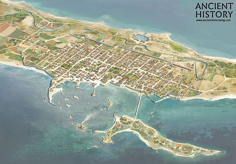
Alexander the Great possibly christened around 70 settlements from Africa to Asia after his own name (along with at least one after his horse’s name). The small Egyptian port town of Rhacotis, with its natural harbor and proximity to the Nile delta, was one of those ‘chosen’ settlements, and it was thus rechristened ‘Alexandria’ in 331 BC.
But of course, beyond just the new name, the tiny port was also reinvigorated with a brand new suburb constructed beside the old town – with the plan apparently conceived by Alexander himself. And this is what Strabo had to say about the city after almost 300 years of its (re)founding –
The city has magnificent public precincts and royal palaces which cover a fourth or even a third of the entire area. For just as each of the kings would, from a love of splendor, add some ornament to the public monuments, so he would provide himself at his own expense with a residence in addition to those already standing.
Suffice it to say, Alexandria was a thriving city by the 1st century BC known for many of its monumental attractions, like the grand Temple of Serapis that was adjoined to the Great Library of Alexandria. And while the city aptly secured its cultural status as a great center of learning, it also flaunted its commercial glory with the Pharos Lighthouse – constructed on an island by the polis and considered one of the ancient Seven Wonders of the World.
And the good news for us history enthusiasts is – most of these fascinating architectural high points are presented through one of the digital reconstructions concocted by the folks over at AncientVine. As the animation makes it clear at the beginning, the recreation pertains to the setting of this Greco-Roman Egyptian metropolis circa 51 BC.
Another educational video, made from clips of the video game Assassins Creed: Origins, presents a pretty detailed overview of the ancient city of Egypt.
Pompeii (circa 1st century AD)
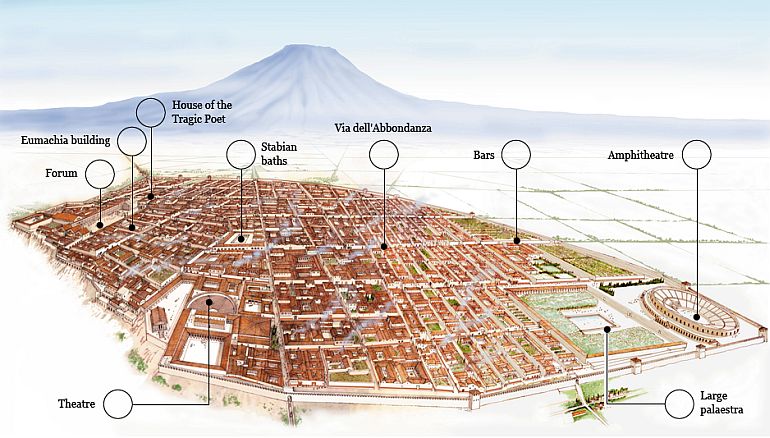
Pompeii, the ancient Roman town-city near modern Naples, boasted an assortment of baths, houses, temples, public structures, graffiti, frescoes, and even a gymnasium and a port. But more than any of these antediluvian avenues, the city is best known for its fascination with disaster for over 400 years, after its rediscovery way back in 1599 AD.
In fact, the site of Pompeii has been a popular tourist destination for over 250 years – thus merging an unfortunate episode of history and the innate level of human curiosity. However, beyond just the ‘popular’ impact of the disaster, there was the historical city of Pompeii – a thriving Roman settlement with over 11,000 in population. In fact, by the late 1st century AD, Pompeii was known for its export of wine and its resort-like characteristics (which explains the bevy of ancient ‘holiday homes’ in the city).
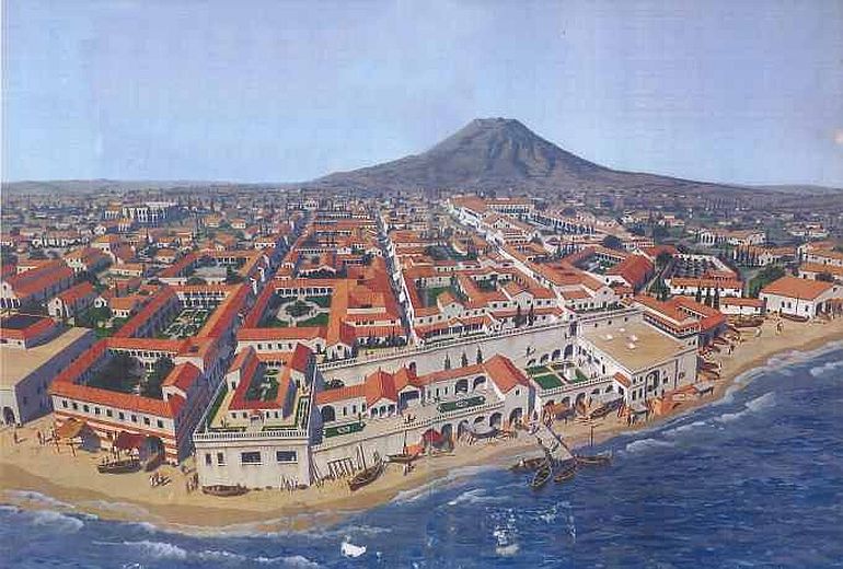
To that end, the folks over at Altair4 Multimedia have concocted one of the superb digital reconstructions that aptly presents the historicity of Pompeii, before it was ‘marred’ by catastrophic events.
And in case you are interested in one of the digital reconstructions that replicate the sheer destruction wrought by Vesuvius, a 2009 exhibition named aptly as the ‘A Day in Pompeii’ was showcased at the Melbourne Museum. Suffice it to say, the exhibition used 3D renderings to present a more accurate picture of the impending disaster that took place in 79 AD, and its baleful effects in the span of 48 hours surrounding the eruption of Mount Vesuvius.
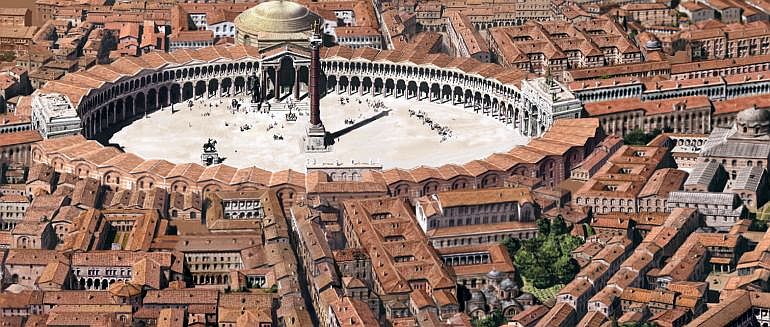
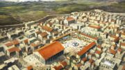
Corinth (circa 2nd century AD)
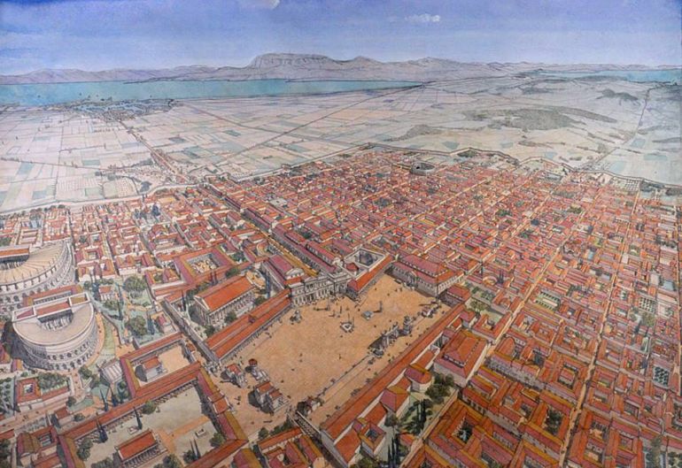
Ancient Corinth was one of the most powerful and important of the Greek city-states, with the settlement itself boasting a population of over 90,000 during the 5th century BC. Guarding the isthmus which connects mainland Greece with the Peloponnese, the strategic location of the city manifested itself throughout its history, with commerce, trade, navies, and wars playing their crucial roles in the Corinthian scheme of things.
The unique geography of the city (with fertile lands and natural springs) even enticed the later Romans, who destroyed the original settlement after their victory over the Achaean League in 146 BC. And Julius Caesar was then instrumental in ‘re-founding’ Colonia Laus Iulia Corinthiensis (‘colony of Corinth in honor of Julius’) circa 44 BC, thus leading to its subsequent revival as the provincial capital of Achaia.
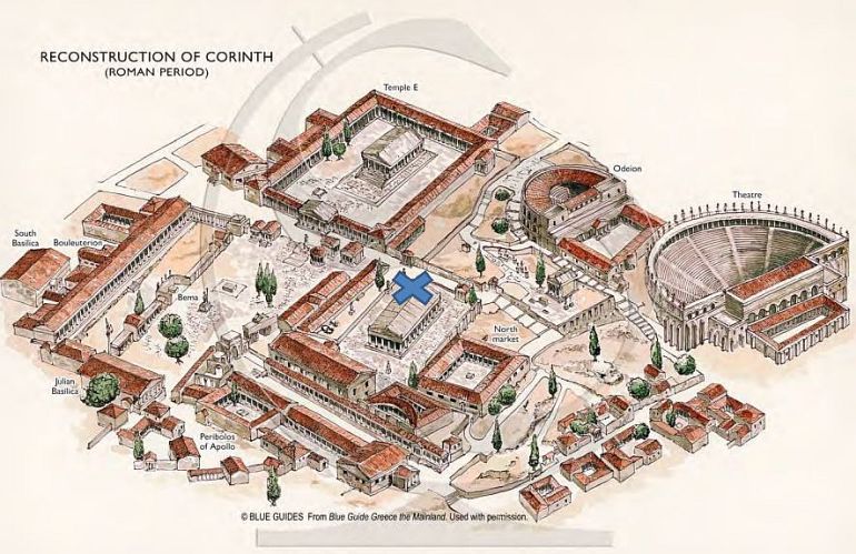
Considering all these dynamic historical factors, animator extraordinaire Danila Loginov has presented one of the digital reconstructions of ancient Corinth, circa 2nd century AD. He goes on to provide a short summary of his recreation –
Reconstruction of ancient Corinth city as it was in II century AD, in Roman Empire ages. It contains the whole city, the central part with Agora, temple of Apollon, theater and Odeon, and also hippodrome, gymnasium, temple of Asclepius and amphitheater. Near the city is Acrocorinth mountain with fortress and temples.
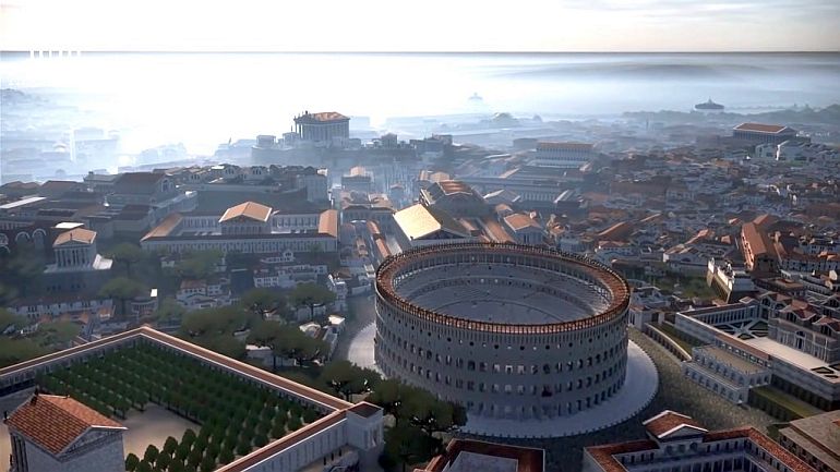
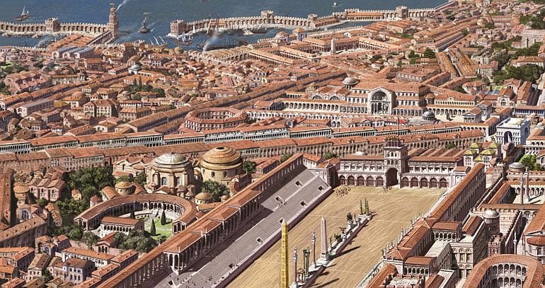
Rome (circa 320 AD)
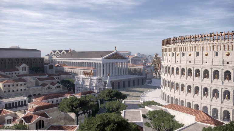
An incredible fruit of collaboration between the Rome Reborn project and Khan Academy, the digital reconstruction presented below gives us a fascinating tour through the ancient megacity in its arguable peak form in 320 AD.
In essence, this was the period when Emperor Constantine was successful in once again centralizing the power of the state, while also endowing freedom of worship for Christians. In many ways, this short epoch of stability became the ‘last hurrah’ of glory for the ancient stronghold – before the Roman Empire was divided, and consequently, Rome lost its significance in the coming centuries.
As overseer of the Rome Reborn project, Dr. Bernard Frischer makes it clear why 320 AD was chosen as the subject of the video tour –
And even beyond just the ‘starring’ emperor, the period of Constantine is crucial for history because that was the time when Rome possibly reached the peak of its population (that easily crossed the threshold of a million people) and urban development. Moreover, even from the perspective of architectural triumphs, this period mirrored the rise of major Christian churches, while the post-era (after 320 AD) defined the unfortunate abandonment of major engineering or constructional undertakings.
Simply put, most of what we know about Rome in our modern age comes from this age, along with the glorious preceding years before the rise of Constantine. Hence Danila Loginov has presented one of his digital reconstructions of the ‘eternal city’ of Rome at its architectural peak, circa 320 AD. Running over 8 minutes of awesomeness, the animation video adds various ancient landmarks such as the temple of Divine Augustus, basilica Argentaria and a few other temples of the Capitoline Hill.
Constantinople (circa 5th century – 13th century AD)
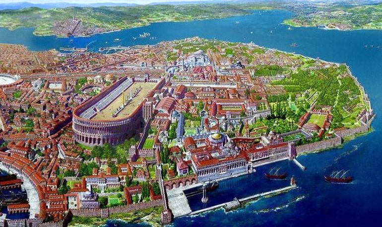
Constantinople was the largest and wealthiest city in Europe from the 5th to early 13th century AD. To that end, it was Emperor Constantine who truly elevated the architectural ambit of the original settlement, by ‘re-founding’ it as Nova Roma (New Rome or Νέα Ῥώμη). This symbolic overture mirrored the entire shifting of the capital from original Rome to Byzantium in 330 AD, which was then called Konstantinoupolis (or City of Constantine).
As we described in one of our previous articles concerning the pictorial reconstruction of Constantinople –
In fact, the massive defense systems of the major Roman city [entailing the Theodosian Walls] were equally matched by its impressive architectural masterpieces, ranging from the magnificent Greek Orthodox cathedral of Hagia Sophia, the humongous Hippodrome of Constantinople (which was capable of possibly holding over 50,000 spectators) to the Great Palace of Constantinople (or Palatium Magnum or Μέγα Παλάτιον) and the triumphal Golden Gate of the complex Land Walls.
In reference to the flurry of these architectural and engineering credentials, Constantinople in itself was also called Roma Constantinopolitana, sometimes accompanied by prestigious titles such as Basileuousa (Queen of Cities) and Megalopolis (the Great City).
And as for the massive Theodosian Walls of Constantinople, they are often heralded as one of the greatest fortification systems devised in the history of warfare. Constructed circa the 5th century AD, the fortification was famed for its double lines and complex spatial elements.
In fact, beyond just its sheer scale and size that encompassed a whopping 5.5 km (3.4 miles) of the city’s parameter, the testament to the effectiveness of these walls is history itself – with the massive fortified system playing its crucial role in defending Constantinople from the siege attempts of Avars, Arabs, Rus and Bulgars – and that too over a period of 800 years.
Inspired by all these defense-worthy credentials, YouTuber Invicta has concocted one of the better digital reconstructions that aptly presents the history and physical scope of the mighty Theodosian Walls, with the aid of the Total War game engine.


Be the first to comment on "10 Famous Ancient Cities Reconstructed"